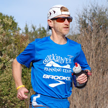
 Two other pictures also illustrate the run: one taken at the start (see the cloudy sky) and one at the finish.
 From dry to cold and completely soaked...
 With only on Snicker bar and one pack of GU gel, the 350 calories did not come close to the 2,800 calories spent during this long run, per SportTracks’ estimate. After 5 hours in bad weather, I arrived completely depleted in Manson, to visit Agnès' cousins in their family vacation home. I was welcomed by Pierre whom I begged to bring me some food before I could get inside to take a shower and warm up near the fire. The thermometer went over 90F yesterday, but below 50F today; what a difference this makes, not to mention gusty wins, rain and hail! Pierre even served me a glass of wine, from Burgundy: the French way!
 Rain was on and off in the morning but I got caught in a hail storm at the top of Puy de Dôme where I stopped for 30 minutes hoping the storm would pass. As the weather was not improving, I plunged in the steep Chemin des Mûletiers, despite the heavy rain and gusty winds.
Overall I covered 29 miles (47 kilometers) across most of the “Puys”, this chain of lava domes and cinder cones. Much more compact than the one in Oregon, with summits a few miles or less than a mile from each other. A great place to run with many trails and amazing views to hundreds miles away in all directions. My run would have been a marathon if I did not get lost two times despite the very detailed map that Henri gave me in the morning. This says long on my limited experience with orienteering and why I appreciate so much the abundant ribbons and markings on our Californian trail races...
I included a few names of the 48 dormant volcanoes over the map below and here is the list of villages and other special points of my trek through the Chaîne des Puys. (Click on the picture to enlarge.)

- Banzat
- Les Mauvaises
- Malauzat
- La Chaume
- Argnat
- Chanat-la-Mouteyre
- La Mouteyre
- Chanat-la-Mouteyre (oops, again!)
- Puy des Goules
- Grotte du Sarcoui
- Puy Pariou
- Puy de Dôme
- Col de Ceyssat
- Croix Espinasse
- Laschamp
- D767A (instead of D767, adding 2.5 miles…)
- Chapelle St Aubin
- Manson
I like to share about my runs in Europe, hoping my reports come useful to people on the go looking at some directions and running course ideas. However, I expect this one to be of limited use because of the point to point nature of it, from the middle of nowhere to the middle of nowhere else, I mean unlikely places for tourists to visit. That said, the ascent to the summit of Puy de Dôme is a famous stage of the Tour de France, and very much worth the climb by foot too if you ever visit Clermont-Ferrand, the Michelin Capital.
Next stops of our own Tour de France: Lyon to pick Max at the airport after his two-week stay in Salamanca, Spain, then Annecy to visit Agnès’ parents and Chamonix where we stay for a week and where I hope to run the Ultra Trail du Mont Blanc (UTMB) course over two days (weather permitting). Talk to you from the Alps, if and when I get close to a wifi hot spot!


.jpg )

1 comment:
Pas de vacances pour le coureur,donc!
Pas de chance avec le temps (weather)
Bises
Maman
Post a Comment