I'm not sure this is going to be a very popular or useful post. First, this Japanese National Park is really not on the beaten paths for foreigners, least so for runners and likely not for my blog followers. Second, we had such a bad weather for our whole stay, we couldn't see a thing which is quite unfortunate given the exceptional scenic landscapes this active volcanic area has to offer. Yet, I found so little help to prepare my runs while we stayed in this Park, I hope this will be useful to some people... And to provide a nice virtual visit of this part of Hokkaido in case you don't have the opportunity to visit, I even included a few videos for once. Now making for a long post by combining 3 long runs...
The Park is given as the 14th largest of Japan's National Parks and is the closest one to Sapporo in Hokkaido. There is even a direct bus shuttle from the New Chitose International airport to Lake Shikotsu and numerous trains riding along the Pacific Coast of this western Peninsula of Hokkaido. With some persistence, Agnès even found a shuttle between downtown Sapporo and our first hotel in Noberibetsu Onsen.
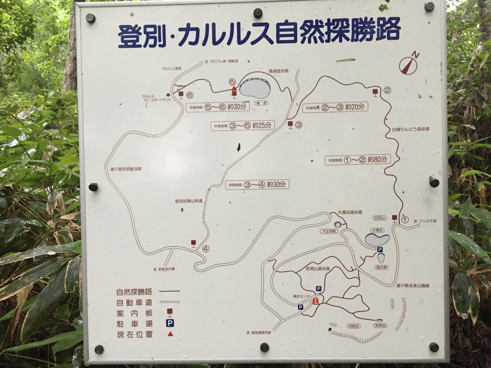
Our first stop in Noboribetsu was at the tourist center when I asked for a map of the trails. We were helped by a Japanese person speaking a perfect English which has been quite rare during our week in Hokkaido. While she was very nice, the indications she gave me were quite disappointing as she kept pointing to the 'trails' of the Hell Valley, trails which length were given between 229 and 599 meters (Japanese like precision, don't they?). When I mentioned that I had run 30 kilometers the day before, she almost rolled her eyes and added that that's all it was in the area, that even the road going up to the famous Lake Kuttara was closed because of the bad weather and danger of mud slides.
Well, a couple of hours later, I left the Hell Valley and hopped on that road which was actually better than any of our roads in California. The asphalt was so slick it made the climb up that first volcano quite smooth and easy, it felt like being on a Formula 1 road circuit! However, yes, the weather was quite bad, alternating between pouring rain and fog; so long for the view and the pictures... Here is the view I got of Lake Kuttara, from the shore of the lake and from the ridge of the crater. I told you, I couldn't see a thing...


From a running recommendation standpoint, there are a few narrow sections on that road where you'd have to be careful if two mega buses cross each other. But otherwise, there is a good marking on each side which leaves some room for foot and bike traffic.


Too tempting to pass on the invitation, I went on that trail, which looked really nice, at the beginning...


I was already soaked from the rain, humidity and sweat but that got worse: running creeks, wet leaves on each side of the trail and mud swamps got the soaking to another level! I had to spend some time in the evening drying my running shoes with the hair dryer at the hotel...
With the approximate picture of the above trail map in my mind, I ended up on the wrong trail and turned back when my GPS watch indicated that I had missed my target by at least a mile. On my way back, my phone got coverage and I was able to send a Whatsapp text message to Agnès to tell her I was still ok and on my way back. To be honest I had no idea about the way to get back to the hotel at that point and glad that, short of showing a trail, Google maps was showing me which side the onsen was. After some wandering, I got back to the wrong turn I had taken and on the right trail.


Uploading my Garmin data on Strava, I could see what I did on the map and what to do to get to this lake, Lake Tachiba, the next day...

Overall, with more than 3,200 feet, some good elevation for 20 miles.
With dried shoes that Friday morning I went back in the... rain and got drenched again as I approached and did a loop around Lake Tachiba. The trail was easy to find this time but quite damaged by the heavy rain which fell all week. Luckily, as I was finishing the one-mile loop, the fog opened up a bit so I could get a glimpse of the amazing turquoise color of the shallow water.
While the nearby Lake Kuttara is said to be the second cleanest water in Japan with under water visibility up to 20 meters, Lake Tachiba has a flat bottom and the depth doesn't seem to exceed 3 or 4 feet so the water looked crystal clear. I was surprised to see quite a few fish enjoying this super quiet place. Here is a short video, sorry again for the lack of sun and blue sky...
And a few pictures of that area which must look even much nicer with more light.

 In this weather, I certainly didn't see anybody during my run but, given this looks like the only major hiking trail in the area, albeit 4 mile-long, I assume a few hikers must go through this area when the weather is better. At least, and despite the obvious recent damage due to the rain, the trail looked somehow maintained.


And this map again which is a key resource if you want to explore the area:
This other onsen though, Karurusu Onsen, was a tiny one with only one hotel. I was looking forward to finding a 7 Eleven to get some water and ice cream, but there was not a single shop to be found around. I did stop by the tiny post office where the nice owners accepted to fill up my water bottle. I came back to Noboribetsu on the road, yet another very smooth asphalt with ample room on the side to run safely against the traffic.
Back to Noboribetsu, I joined the flocks of tourists and ran and stopped by all the recommended spots, starting with the famous natural foot bath (natural spring of sulphur water between 100-110F, 40-43C):
The sulfurous Lake Oyunama:
 The picturesque Hell Valley where the sulfur prevents any vegetation to grow.
 And the episodic geyser Tessen-Ike with boiling water and steam:


Are you getting confused with my report yet? Here is an annotated map of my second run, mapping out some of the aforementioned names and locations...

On Saturday, our third day in the Park, we spent 3 hours to switch places, to Lake Shikotsu Onsen, on the eastern side/entrance of the Park: 1 bus down to the Noboribetsu train station, one train to Tomakomai, another train to Chitose, and a bus for the remaining 25 km up to Lake Shikotsu. Same drill, a stop by the visitor/tourist center to get local maps on which I quickly spotted an interesting challenge, running to the top of Mt. Tarumae which is a volcano still in activity, exhibiting some flumes. With a detour though the Morappu campsite, it took me 9.5 miles to get to the bottom of the volcano but, again, not seeing a thing due to the dense cloud. What a disappointment for the missed picture opportunities, yet I was glad I was able to do this quick climb before night fall as we were visiting the place for less than 18 hours...


Here is view situating my run on the East side of the Shikotsu-Toya National Park:

90 miles in 5 days while on Hokkaido, not too shabby given the bad weather we had, and the public transportation commutes between the three places we stayed at. My reports would have surely been different would have we enjoyed blue skies and stunning views of this volcanic area. Overall, the trail running and hiking opportunities weren't as abundant as in Scotland for instance. For one thing, the Japanese are very serious about security as you can see from the road marking and the comments from the visitor centers' staff advising against venturing off the beaten paths. Second, there is obviously the language barrier which prevents from asking for directions or even reading the signs, all in Japanese. A bit disappointing in a country so addicted to ultra trail running. Speaking of which, I had considered running an ultra race last weekend but the website and registration process were all in Japanese and the race director never replied to my emails. Yes, Japan is quite a special place to visit, and not an easy one with this language barrier. More than anywhere else, you have to ask a lot of questions here...


.jpg )


No comments:
Post a Comment